Winter storm becoming more likely in North Carolina mid-week – WRAL News
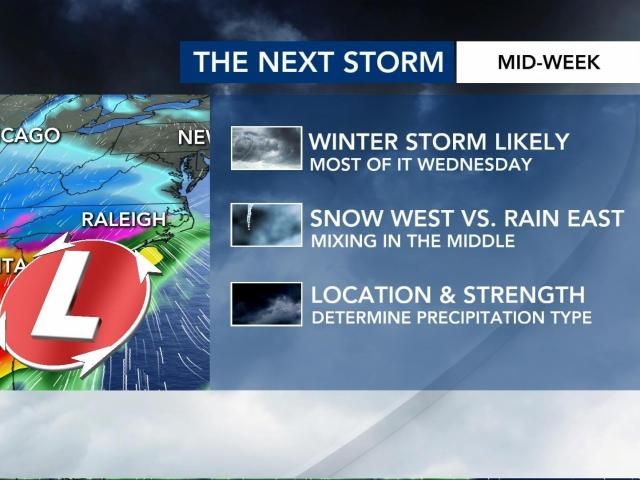
A winter storm arrives late Wednesday morning, bringing snow to areas north of Interstate 40 and a mixed bag to the south. Travel will be impacted. Power outages are to-be-determined. First-call numbers will come out either midday Monday or during the afternoon.Bullet points for Wednesday’s winter stormKeep reading below to see what we’re tracking, what the possible scenarios are and when we expect to know more.Where is the storm right now?As of this posting Monday morning, the storm is finally over the western U.S. More specifically, its energy is over Washington state.This is crucial to the forecast process, because weather balloons will now get into the storm. These balloons collect data that gets fed into our forecast modeling.The storm is over the Western U.S. as of Monday morningModels have big discrepancies in the snow vs. freezing rain line over our area – even 54 hours out from the start of the storm.Where am I on a map?It’s important to know where you are on this map. This will alleviate any confusion as to “how much will I get?” or “when will it start?”Counties that WRAL coversWhen will you put out maps with totals?The first-call maps for snow and ice will likely come out either midday/early afternoon Monday.Once the morning model runs have the aformentioned balloon data in them, we’ll feel at least a little more confident in numbers.For now, let’s focus on the impact. Impact is more important than numbers, in my opinion.When does it start, and how will it affect me?I do not think you’re going to wake up at 6 or 7 a.m. Wednesday to snow on the ground or ice in the trees. There’s some dry air to overcome at first. Therefore, we expect things to start up after 9 or 10 a.m.Timing and threats for Wednesday’s winter stormFrom there, we’ll see the storm off-and-on for about a 9-to-12 hour time span.The main concern is the impact to travel – both on the road and in the air. That is almost a given. Power outages will be possible if ice totals get to 0.25 inches or above. That is certainly possible from Wake County southward.Who sees what?The general trend is for there to be more snow north of I-40. This could be several inches – especially in the northeastern corner of our viewing area.South of that point, we expect more of an icy mix. A difference of one degree 3,000 feet above our heads makes the difference between snow, sleet and freezing rain. That’s why this is such a delicate forecast. A shift of 25 to 50 miles in the track of the storm makes a difference in the map you see below.Precipitation types expected with Wednesday’s winter stormAre you concerned about power outages?The areas in the pink below need to be watched for potential power outages. If ice totals get toward 0.25 inches, which is possible, that adds at least 500 pounds of weight onto power lines.Potential for power outages due to ice WednesdayWhat are your thoughts on schools, appointments, etc.?That decision doesn’t come from us. That said, I would imagine there will be changes to school and/or scheduled appointments Wednesday and/or Thursday.I have to travel Wednesday. What’s it looking like?The coast sees more rain than anything else, although some inland areas could see some freezing rain too. The western half of the state will see some snow and sleet. If you can travel Tuesday evening, I think that’s your best bet for safety and timely purposes.Keep reading below to see what we’re tracking, what the possible scenarios are and when we expect to know more.Where is the storm right now?As of this posting Monday morning, the storm is finally over the western U.S. More specifically, its energy is over Washington state.This is crucial to the forecast process, because weather balloons will now get into the storm. These balloons collect data that gets fed into our forecast modeling.The storm is over the Western U.S. as of Monday morningModels have big discrepancies in the snow vs. freezing rain line over our area – even 54 hours out from the start of the storm.Where am I on a map?It’s important to know where you are on this map. This will alleviate any confusion as to “how much will I get?” or “when will it start?”Counties that WRAL coversWhen will you put out maps with totals?The first-call maps for snow and ice will likely come out either midday/early afternoon Monday.Once the morning model runs have the aformentioned balloon data in them, we’ll feel at least a little more confident in numbers.For now, let’s focus on the impact. Impact is more important than numbers, in my opinion.When does it start, and how will it affect me?I do not think you’re going to wake up at 6 or 7 a.m. Wednesday to snow on the ground or ice in the trees. There’s some dry air to overcome at first. Therefore, we expect things to start up after 9 or 10 a.m.Timing and threats for Wednesday’s winter stormFrom there, we’ll see the storm off-and-on for about a 9-to-12 hour time span.The main concern is the impact to travel – both on the road and in the air. That is almost a given. Power outages will be possible if ice totals get to 0.25 inches or above. That is certainly possible from Wake County southward.Who sees what?The general trend is for there to be more snow north of I-40. This could be several inches – especially in the northeastern corner of our viewing area.South of that point, we expect more of an icy mix. A difference of one degree 3,000 feet above our heads makes the difference between snow, sleet and freezing rain. That’s why this is such a delicate forecast. A shift of 25 to 50 miles in the track of the storm makes a difference in the map you see below.Precipitation types expected with Wednesday’s winter stormAre you concerned about power outages?The areas in the pink below need to be watched for potential power outages. If ice totals get toward 0.25 inches, which is possible, that adds at least 500 pounds of weight onto power lines.Potential for power outages due to ice WednesdayWhat are your thoughts on schools, appointments, etc.?That decision doesn’t come from us. That said, I would imagine there will be changes to school and/or scheduled appointments Wednesday and/or Thursday.I have to travel Wednesday. What’s it looking like?The coast sees more rain than anything else, although some inland areas could see some freezing rain too. The western half of the state will see some snow and sleet. If you can travel Tuesday evening, I think that’s your best bet for safety and timely purposes.As of this posting Monday morning, the storm is finally over the western U.S. More specifically, its energy is over Washington state.This is crucial to the forecast process, because weather balloons will now get into the storm. These balloons collect data that gets fed into our forecast modeling.The storm is over the Western U.S. as of Monday morningModels have big discrepancies in the snow vs. freezing rain line over our area – even 54 hours out from the start of the storm.Where am I on a map?It’s important to know where you are on this map. This will alleviate any confusion as to “how much will I get?” or “when will it start?”Counties that WRAL coversWhen will you put out maps with totals?The first-call maps for snow and ice will likely come out either midday/early afternoon Monday.Once the morning model runs have the aformentioned balloon data in them, we’ll feel at least a little more confident in numbers.For now, let’s focus on the impact. Impact is more important than numbers, in my opinion.When does it start, and how will it affect me?I do not think you’re going to wake up at 6 or 7 a.m. Wednesday to snow on the ground or ice in the trees. There’s some dry air to overcome at first. Therefore, we expect things to start up after 9 or 10 a.m.Timing and threats for Wednesday’s winter stormFrom there, we’ll see the storm off-and-on for about a 9-to-12 hour time span.The main concern is the impact to travel – both on the road and in the air. That is almost a given. Power outages will be possible if ice totals get to 0.25 inches or above. That is certainly possible from Wake County southward.Who sees what?The general trend is for there to be more snow north of I-40. This could be several inches – especially in the northeastern corner of our viewing area.South of that point, we expect more of an icy mix. A difference of one degree 3,000 feet above our heads makes the difference between snow, sleet and freezing rain. That’s why this is such a delicate forecast. A shift of 25 to 50 miles in the track of the storm makes a difference in the map you see below.Precipitation types expected with Wednesday’s winter stormAre you concerned about power outages?The areas in the pink below need to be watched for potential power outages. If ice totals get toward 0.25 inches, which is possible, that adds at least 500 pounds of weight onto power lines.Potential for power outages due to ice WednesdayWhat are your thoughts on schools, appointments, etc.?That decision doesn’t come from us. That said, I would imagine there will be changes to school and/or scheduled appointments Wednesday and/or Thursday.I have to travel Wednesday. What’s it looking like?The coast sees more rain than anything else, although some inland areas could see some freezing rain too. The western half of the state will see some snow and sleet. If you can travel Tuesday evening, I think that’s your best bet for safety and timely purposes.This is crucial to the forecast process, because weather balloons will now get into the storm. These balloons collect data that gets fed into our forecast modeling.The storm is over the Western U.S. as of Monday morningModels have big discrepancies in the snow vs. freezing rain line over our area – even 54 hours out from the start of the storm.Where am I on a map?It’s important to know where you are on this map. This will alleviate any confusion as to “how much will I get?” or “when will it start?”Counties that WRAL coversWhen will you put out maps with totals?The first-call maps for snow and ice will likely come out either midday/early afternoon Monday.Once the morning model runs have the aformentioned balloon data in them, we’ll feel at least a little more confident in numbers.For now, let’s focus on the impact. Impact is more important than numbers, in my opinion.When does it start, and how will it affect me?I do not think you’re going to wake up at 6 or 7 a.m. Wednesday to snow on the ground or ice in the trees. There’s some dry air to overcome at first. Therefore, we expect things to start up after 9 or 10 a.m.Timing and threats for Wednesday’s winter stormFrom there, we’ll see the storm off-and-on for about a 9-to-12 hour time span.The main concern is the impact to travel – both on the road and in the air. That is almost a given. Power outages will be possible if ice totals get to 0.25 inches or above. That is certainly possible from Wake County southward.Who sees what?The general trend is for there to be more snow north of I-40. This could be several inches – especially in the northeastern corner of our viewing area.South of that point, we expect more of an icy mix. A difference of one degree 3,000 feet above our heads makes the difference between snow, sleet and freezing rain. That’s why this is such a delicate forecast. A shift of 25 to 50 miles in the track of the storm makes a difference in the map you see below.Precipitation types expected with Wednesday’s winter stormAre you concerned about power outages?The areas in the pink below need to be watched for potential power outages. If ice totals get toward 0.25 inches, which is possible, that adds at least 500 pounds of weight onto power lines.Potential for power outages due to ice WednesdayWhat are your thoughts on schools, appointments, etc.?That decision doesn’t come from us. That said, I would imagine there will be changes to school and/or scheduled appointments Wednesday and/or Thursday.I have to travel Wednesday. What’s it looking like?The coast sees more rain than anything else, although some inland areas could see some freezing rain too. The western half of the state will see some snow and sleet. If you can travel Tuesday evening, I think that’s your best bet for safety and timely purposes.Models have big discrepancies in the snow vs. freezing rain line over our area – even 54 hours out from the start of the storm.Where am I on a map?It’s important to know where you are on this map. This will alleviate any confusion as to “how much will I get?” or “when will it start?”Counties that WRAL coversWhen will you put out maps with totals?The first-call maps for snow and ice will likely come out either midday/early afternoon Monday.Once the morning model runs have the aformentioned balloon data in them, we’ll feel at least a little more confident in numbers.For now, let’s focus on the impact. Impact is more important than numbers, in my opinion.When does it start, and how will it affect me?I do not think you’re going to wake up at 6 or 7 a.m. Wednesday to snow on the ground or ice in the trees. There’s some dry air to overcome at first. Therefore, we expect things to start up after 9 or 10 a.m.Timing and threats for Wednesday’s winter stormFrom there, we’ll see the storm off-and-on for about a 9-to-12 hour time span.The main concern is the impact to travel – both on the road and in the air. That is almost a given. Power outages will be possible if ice totals get to 0.25 inches or above. That is certainly possible from Wake County southward.Who sees what?The general trend is for there to be more snow north of I-40. This could be several inches – especially in the northeastern corner of our viewing area.South of that point, we expect more of an icy mix. A difference of one degree 3,000 feet above our heads makes the difference between snow, sleet and freezing rain. That’s why this is such a delicate forecast. A shift of 25 to 50 miles in the track of the storm makes a difference in the map you see below.Precipitation types expected with Wednesday’s winter stormAre you concerned about power outages?The areas in the pink below need to be watched for potential power outages. If ice totals get toward 0.25 inches, which is possible, that adds at least 500 pounds of weight onto power lines.Potential for power outages due to ice WednesdayWhat are your thoughts on schools, appointments, etc.?That decision doesn’t come from us. That said, I would imagine there will be changes to school and/or scheduled appointments Wednesday and/or Thursday.I have to travel Wednesday. What’s it looking like?The coast sees more rain than anything else, although some inland areas could see some freezing rain too. The western half of the state will see some snow and sleet. If you can travel Tuesday evening, I think that’s your best bet for safety and timely purposes.It’s important to know where you are on this map. This will alleviate any confusion as to “how much will I get?” or “when will it start?”Counties that WRAL coversWhen will you put out maps with totals?The first-call maps for snow and ice will likely come out either midday/early afternoon Monday.Once the morning model runs have the aformentioned balloon data in them, we’ll feel at least a little more confident in numbers.For now, let’s focus on the impact. Impact is more important than numbers, in my opinion.When does it start, and how will it affect me?I do not think you’re going to wake up at 6 or 7 a.m. Wednesday to snow on the ground or ice in the trees. There’s some dry air to overcome at first. Therefore, we expect things to start up after 9 or 10 a.m.Timing and threats for Wednesday’s winter stormFrom there, we’ll see the storm off-and-on for about a 9-to-12 hour time span.The main concern is the impact to travel – both on the road and in the air. That is almost a given. Power outages will be possible if ice totals get to 0.25 inches or above. That is certainly possible from Wake County southward.Who sees what?The general trend is for there to be more snow north of I-40. This could be several inches – especially in the northeastern corner of our viewing area.South of that point, we expect more of an icy mix. A difference of one degree 3,000 feet above our heads makes the difference between snow, sleet and freezing rain. That’s why this is such a delicate forecast. A shift of 25 to 50 miles in the track of the storm makes a difference in the map you see below.Precipitation types expected with Wednesday’s winter stormAre you concerned about power outages?The areas in the pink below need to be watched for potential power outages. If ice totals get toward 0.25 inches, which is possible, that adds at least 500 pounds of weight onto power lines.Potential for power outages due to ice WednesdayWhat are your thoughts on schools, appointments, etc.?That decision doesn’t come from us. That said, I would imagine there will be changes to school and/or scheduled appointments Wednesday and/or Thursday.I have to travel Wednesday. What’s it looking like?The coast sees more rain than anything else, although some inland areas could see some freezing rain too. The western half of the state will see some snow and sleet. If you can travel Tuesday evening, I think that’s your best bet for safety and timely purposes.The first-call maps for snow and ice will likely come out either midday/early afternoon Monday.Once the morning model runs have the aformentioned balloon data in them, we’ll feel at least a little more confident in numbers.For now, let’s focus on the impact. Impact is more important than numbers, in my opinion.When does it start, and how will it affect me?I do not think you’re going to wake up at 6 or 7 a.m. Wednesday to snow on the ground or ice in the trees. There’s some dry air to overcome at first. Therefore, we expect things to start up after 9 or 10 a.m.Timing and threats for Wednesday’s winter stormFrom there, we’ll see the storm off-and-on for about a 9-to-12 hour time span.The main concern is the impact to travel – both on the road and in the air. That is almost a given. Power outages will be possible if ice totals get to 0.25 inches or above. That is certainly possible from Wake County southward.Who sees what?The general trend is for there to be more snow north of I-40. This could be several inches – especially in the northeastern corner of our viewing area.South of that point, we expect more of an icy mix. A difference of one degree 3,000 feet above our heads makes the difference between snow, sleet and freezing rain. That’s why this is such a delicate forecast. A shift of 25 to 50 miles in the track of the storm makes a difference in the map you see below.Precipitation types expected with Wednesday’s winter stormAre you concerned about power outages?The areas in the pink below need to be watched for potential power outages. If ice totals get toward 0.25 inches, which is possible, that adds at least 500 pounds of weight onto power lines.Potential for power outages due to ice WednesdayWhat are your thoughts on schools, appointments, etc.?That decision doesn’t come from us. That said, I would imagine there will be changes to school and/or scheduled appointments Wednesday and/or Thursday.I have to travel Wednesday. What’s it looking like?The coast sees more rain than anything else, although some inland areas could see some freezing rain too. The western half of the state will see some snow and sleet. If you can travel Tuesday evening, I think that’s your best bet for safety and timely purposes.Once the morning model runs have the aformentioned balloon data in them, we’ll feel at least a little more confident in numbers.For now, let’s focus on the impact. Impact is more important than numbers, in my opinion.When does it start, and how will it affect me?I do not think you’re going to wake up at 6 or 7 a.m. Wednesday to snow on the ground or ice in the trees. There’s some dry air to overcome at first. Therefore, we expect things to start up after 9 or 10 a.m.Timing and threats for Wednesday’s winter stormFrom there, we’ll see the storm off-and-on for about a 9-to-12 hour time span.The main concern is the impact to travel – both on the road and in the air. That is almost a given. Power outages will be possible if ice totals get to 0.25 inches or above. That is certainly possible from Wake County southward.Who sees what?The general trend is for there to be more snow north of I-40. This could be several inches – especially in the northeastern corner of our viewing area.South of that point, we expect more of an icy mix. A difference of one degree 3,000 feet above our heads makes the difference between snow, sleet and freezing rain. That’s why this is such a delicate forecast. A shift of 25 to 50 miles in the track of the storm makes a difference in the map you see below.Precipitation types expected with Wednesday’s winter stormAre you concerned about power outages?The areas in the pink below need to be watched for potential power outages. If ice totals get toward 0.25 inches, which is possible, that adds at least 500 pounds of weight onto power lines.Potential for power outages due to ice WednesdayWhat are your thoughts on schools, appointments, etc.?That decision doesn’t come from us. That said, I would imagine there will be changes to school and/or scheduled appointments Wednesday and/or Thursday.I have to travel Wednesday. What’s it looking like?The coast sees more rain than anything else, although some inland areas could see some freezing rain too. The western half of the state will see some snow and sleet. If you can travel Tuesday evening, I think that’s your best bet for safety and timely purposes.For now, let’s focus on the impact. Impact is more important than numbers, in my opinion.When does it start, and how will it affect me?I do not think you’re going to wake up at 6 or 7 a.m. Wednesday to snow on the ground or ice in the trees. There’s some dry air to overcome at first. Therefore, we expect things to start up after 9 or 10 a.m.Timing and threats for Wednesday’s winter stormFrom there, we’ll see the storm off-and-on for about a 9-to-12 hour time span.The main concern is the impact to travel – both on the road and in the air. That is almost a given. Power outages will be possible if ice totals get to 0.25 inches or above. That is certainly possible from Wake County southward.Who sees what?The general trend is for there to be more snow north of I-40. This could be several inches – especially in the northeastern corner of our viewing area.South of that point, we expect more of an icy mix. A difference of one degree 3,000 feet above our heads makes the difference between snow, sleet and freezing rain. That’s why this is such a delicate forecast. A shift of 25 to 50 miles in the track of the storm makes a difference in the map you see below.Precipitation types expected with Wednesday’s winter stormAre you concerned about power outages?The areas in the pink below need to be watched for potential power outages. If ice totals get toward 0.25 inches, which is possible, that adds at least 500 pounds of weight onto power lines.Potential for power outages due to ice WednesdayWhat are your thoughts on schools, appointments, etc.?That decision doesn’t come from us. That said, I would imagine there will be changes to school and/or scheduled appointments Wednesday and/or Thursday.I have to travel Wednesday. What’s it looking like?The coast sees more rain than anything else, although some inland areas could see some freezing rain too. The western half of the state will see some snow and sleet. If you can travel Tuesday evening, I think that’s your best bet for safety and timely purposes.I do not think you’re going to wake up at 6 or 7 a.m. Wednesday to snow on the ground or ice in the trees. There’s some dry air to overcome at first. Therefore, we expect things to start up after 9 or 10 a.m.Timing and threats for Wednesday’s winter stormFrom there, we’ll see the storm off-and-on for about a 9-to-12 hour time span.The main concern is the impact to travel – both on the road and in the air. That is almost a given. Power outages will be possible if ice totals get to 0.25 inches or above. That is certainly possible from Wake County southward.Who sees what?The general trend is for there to be more snow north of I-40. This could be several inches – especially in the northeastern corner of our viewing area.South of that point, we expect more of an icy mix. A difference of one degree 3,000 feet above our heads makes the difference between snow, sleet and freezing rain. That’s why this is such a delicate forecast. A shift of 25 to 50 miles in the track of the storm makes a difference in the map you see below.Precipitation types expected with Wednesday’s winter stormAre you concerned about power outages?The areas in the pink below need to be watched for potential power outages. If ice totals get toward 0.25 inches, which is possible, that adds at least 500 pounds of weight onto power lines.Potential for power outages due to ice WednesdayWhat are your thoughts on schools, appointments, etc.?That decision doesn’t come from us. That said, I would imagine there will be changes to school and/or scheduled appointments Wednesday and/or Thursday.I have to travel Wednesday. What’s it looking like?The coast sees more rain than anything else, although some inland areas could see some freezing rain too. The western half of the state will see some snow and sleet. If you can travel Tuesday evening, I think that’s your best bet for safety and timely purposes.From there, we’ll see the storm off-and-on for about a 9-to-12 hour time span.The main concern is the impact to travel – both on the road and in the air. That is almost a given. Power outages will be possible if ice totals get to 0.25 inches or above. That is certainly possible from Wake County southward.Who sees what?The general trend is for there to be more snow north of I-40. This could be several inches – especially in the northeastern corner of our viewing area.South of that point, we expect more of an icy mix. A difference of one degree 3,000 feet above our heads makes the difference between snow, sleet and freezing rain. That’s why this is such a delicate forecast. A shift of 25 to 50 miles in the track of the storm makes a difference in the map you see below.Precipitation types expected with Wednesday’s winter stormAre you concerned about power outages?The areas in the pink below need to be watched for potential power outages. If ice totals get toward 0.25 inches, which is possible, that adds at least 500 pounds of weight onto power lines.Potential for power outages due to ice WednesdayWhat are your thoughts on schools, appointments, etc.?That decision doesn’t come from us. That said, I would imagine there will be changes to school and/or scheduled appointments Wednesday and/or Thursday.I have to travel Wednesday. What’s it looking like?The coast sees more rain than anything else, although some inland areas could see some freezing rain too. The western half of the state will see some snow and sleet. If you can travel Tuesday evening, I think that’s your best bet for safety and timely purposes.The main concern is the impact to travel – both on the road and in the air. That is almost a given. Power outages will be possible if ice totals get to 0.25 inches or above. That is certainly possible from Wake County southward.Who sees what?The general trend is for there to be more snow north of I-40. This could be several inches – especially in the northeastern corner of our viewing area.South of that point, we expect more of an icy mix. A difference of one degree 3,000 feet above our heads makes the difference between snow, sleet and freezing rain. That’s why this is such a delicate forecast. A shift of 25 to 50 miles in the track of the storm makes a difference in the map you see below.Precipitation types expected with Wednesday’s winter stormAre you concerned about power outages?The areas in the pink below need to be watched for potential power outages. If ice totals get toward 0.25 inches, which is possible, that adds at least 500 pounds of weight onto power lines.Potential for power outages due to ice WednesdayWhat are your thoughts on schools, appointments, etc.?That decision doesn’t come from us. That said, I would imagine there will be changes to school and/or scheduled appointments Wednesday and/or Thursday.I have to travel Wednesday. What’s it looking like?The coast sees more rain than anything else, although some inland areas could see some freezing rain too. The western half of the state will see some snow and sleet. If you can travel Tuesday evening, I think that’s your best bet for safety and timely purposes.The general trend is for there to be more snow north of I-40. This could be several inches – especially in the northeastern corner of our viewing area.South of that point, we expect more of an icy mix. A difference of one degree 3,000 feet above our heads makes the difference between snow, sleet and freezing rain. That’s why this is such a delicate forecast. A shift of 25 to 50 miles in the track of the storm makes a difference in the map you see below.Precipitation types expected with Wednesday’s winter stormAre you concerned about power outages?The areas in the pink below need to be watched for potential power outages. If ice totals get toward 0.25 inches, which is possible, that adds at least 500 pounds of weight onto power lines.Potential for power outages due to ice WednesdayWhat are your thoughts on schools, appointments, etc.?That decision doesn’t come from us. That said, I would imagine there will be changes to school and/or scheduled appointments Wednesday and/or Thursday.I have to travel Wednesday. What’s it looking like?The coast sees more rain than anything else, although some inland areas could see some freezing rain too. The western half of the state will see some snow and sleet. If you can travel Tuesday evening, I think that’s your best bet for safety and timely purposes.South of that point, we expect more of an icy mix. A difference of one degree 3,000 feet above our heads makes the difference between snow, sleet and freezing rain. That’s why this is such a delicate forecast. A shift of 25 to 50 miles in the track of the storm makes a difference in the map you see below.Precipitation types expected with Wednesday’s winter stormAre you concerned about power outages?The areas in the pink below need to be watched for potential power outages. If ice totals get toward 0.25 inches, which is possible, that adds at least 500 pounds of weight onto power lines.Potential for power outages due to ice WednesdayWhat are your thoughts on schools, appointments, etc.?That decision doesn’t come from us. That said, I would imagine there will be changes to school and/or scheduled appointments Wednesday and/or Thursday.I have to travel Wednesday. What’s it looking like?The coast sees more rain than anything else, although some inland areas could see some freezing rain too. The western half of the state will see some snow and sleet. If you can travel Tuesday evening, I think that’s your best bet for safety and timely purposes.The areas in the pink below need to be watched for potential power outages. If ice totals get toward 0.25 inches, which is possible, that adds at least 500 pounds of weight onto power lines.Potential for power outages due to ice WednesdayWhat are your thoughts on schools, appointments, etc.?That decision doesn’t come from us. That said, I would imagine there will be changes to school and/or scheduled appointments Wednesday and/or Thursday.I have to travel Wednesday. What’s it looking like?The coast sees more rain than anything else, although some inland areas could see some freezing rain too. The western half of the state will see some snow and sleet. If you can travel Tuesday evening, I think that’s your best bet for safety and timely purposes.That decision doesn’t come from us. That said, I would imagine there will be changes to school and/or scheduled appointments Wednesday and/or Thursday.I have to travel Wednesday. What’s it looking like?The coast sees more rain than anything else, although some inland areas could see some freezing rain too. The western half of the state will see some snow and sleet. If you can travel Tuesday evening, I think that’s your best bet for safety and timely purposes.The coast sees more rain than anything else, although some inland areas could see some freezing rain too. The western half of the state will see some snow and sleet. If you can travel Tuesday evening, I think that’s your best bet for safety and timely purposes.Copyright 2025 by Capitol Broadcasting Company. All rights reserved. This material may not be published, broadcast, rewritten or redistributed.
Source: https://www.wral.com/story/winter-storm-becoming-more-likely-in-north-carolina-mid-week/21861357/