See it: SpaceX ‘jellyfish’ spotted across mid-Atlantic, Northeast sky as pair of satellites launch into orbit – Fox Weather
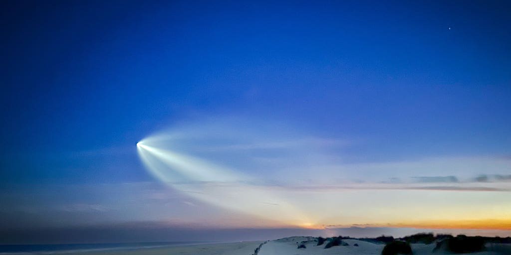
An airplane pilot captured incredible footage of SpaceX’s Falcon 9 rocket launch from the cockpit of a business jet on the evening of Tuesday, February 4.A SpaceX rocket was seen screaming across the eastern U.S. sky after the company launched a pair of MAXAR satellites.SpaceX launched the satellites on Tuesday evening on one of its Falcon 9 rockets from Cape Canaveral Space Force Station in Florida. Fog obscured the view for some along Florida’s Space Coast. However, because of the launch trajectory and final orbit of the satellites, those to the north of the Sunshine State had the best view of this mission.Social media users across the mid-Atlantic and Northeast shared images of the SpaceX “jellyfish” created as the rocket went soaring into the sky.A Feb. 4, 2025 SpaceX rocket launch from Florida was spotted across the East Coast sky, including in Morehead City, North Carolina. SpaceX’s rocket was seen from a plane at 39,000 feet in the video at the top of this story and from the ground in Morehead City, North Carolina.The launch was also visible from Topsail Beach, North Carolina, where this photo was taken.SpaceX’s Falcon 9 rocket launch seen from Topsail Beach, North Carolina, on Feb. 4, 2025. (Max West/X)The jellyfish in the sky was bright on Assateague Island, Maryland, just after sunset, creating a colorful sky in the background. A SpaceX rocket seen from Assateague Island, Maryland on Feb. 4, 2025 after launching from Florida. (Scott Jacobson )Views of the launch put on a vibrant show across the Northeast, even in New York City. MAXAR selected SpaceX to launch its fifth and sixth Worldview Legion satellites into orbit. With its current satellites, the technology company provides high-resolution images of the world, including recent weather events and natural disasters.BEFORE AND AFTER IMAGES SHOW THE EXTENT OF WILDFIRE DAMAGE AROUND LOS ANGELESBefore and after images of Greenfield, Iowa, after an EF-4 tornado tore through the town on May 21, 2024. (Satellite image ©2024 Maxar Technologies / FOX Weather)The company said with the additional eyes in the sky, it will be able to collect up to 3.6 million square miles of imagery every day.
This material may not be published, broadcast, rewritten, or
redistributed. ©2025 FOX News Network, LLC. All
rights reserved.
Source: https://www.foxweather.com/earth-space/video-spacex-rocket-launch-mid-atlantic-northeast-sky