NOAA Satellites Monitor California Wildfires – nesdis
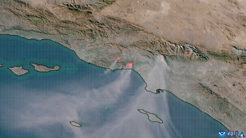
Phenomena: Wildfires, SmokeSatellite: GOES-18 (GOES West) Product: GeoColor, Fire TemperatureInstrument: Advanced Baseline ImagerDate: Jan 9, 2025 (18:00 UTC – 23:56 UTC) NOAA satellites have been closely monitoring multiple wildfires that began erupting in southern California on Tuesday, Jan. 7, 2025 and are continuing to devastate the region. The imagery above, captured via NOAA’s GOES West satellite (GOES-18) over nearly six hours on Thursday, Jan. 9, combines two products: GeoColor, which approximates how the Earth would appear to a human eye in space, and Fire Temperature RGB, which highlights heat signatures and the most intense fires. The imagery also shows thick grayish smoke plumes drifting southwest over California’s Channel Islands. GOES West provides geostationary satellite coverage of the Western Hemisphere, including the United States, the Pacific Ocean, Alaska and Hawaii.Evacuations Save LivesThe fires have prompted the safe evacuation of approximately 153,000 residents as a precautionary measure to protect them from the advancing flames and hazardous conditions. NOAA Satellites: Essential Tools for Wildfire Detection, Monitoring, and Public SafetyNOAA satellites are vital for monitoring and managing wildfires, providing timely information that supports firefighting efforts and protects public safety.NOAA operates two key satellite systems: Geostationary Operational Environmental Satellites (GOES) and polar-orbiting satellites. The GOES-R series, with its Advanced Baseline Imager (ABI), delivers near real-time, high-resolution images that help forecasters locate hotspots, determine a fire’s size and temperature, detect changes in a fire’s behavior, and monitor smoke and air quality. The satellites frequently detect fires before they are spotted on the ground and reported to 911. The ability to monitor smoke plumes in near real-time is particularly useful for directing firefighting efforts from the air. Precise information about the location and motion of smoke guides decisions for deploying firefighting flights. Polar-orbiting satellites, such as those in the Joint Polar Satellite System (JPSS), feature the Visible Infrared Imaging Radiometer Suite (VIIRS), which offers detailed, continuous global fire monitoring. VIIRS excels in detecting smaller, lower-temperature fires with its 375-meter spatial resolution and Day-Night Band, which captures low-intensity visible light for enhanced nighttime fire detection. VIIRS also contributes to the HRRR-smoke model, which forecasts wildfire smoke movement up to 24 hours in advance.NOAA satellites play a pivotal role in fire detection, mapping, and environmental impact assessment. They pinpoint heat signatures, create detailed maps of burned areas and fire perimeters, and track smoke and pollutants to evaluate air quality and health impacts. These capabilities support firefighting agencies in making informed decisions, allocating resources efficiently, and forecasting fire behavior with predictive models.The Hazard Mapping System (HMS) integrates satellite data into a publicly accessible platform that provides daily updates on fire locations and conditions. NOAA collaborates with partners like NASA and the U.S. Forest Service to enhance fire monitoring and share critical information.In an era of increasingly severe wildfires, NOAA satellites provide indispensable tools for protecting communities and managing natural disasters. Their data offers insights into fire dynamics, including location, duration, size, temperature, and power, as well as smoke dispersion, improving air quality forecasts and aiding firefighting efforts.Timely Action Saves LivesIn ever-changing fire environments, timely satellite imagery saves lives. The safe evacuation of over 153,000 residents demonstrates how NOAA’s advanced technology and data empower local authorities to act swiftly, protecting communities and minimizing loss.For more imagery of this event, visit the Satellite Library, run by our partners at the Cooperative Institute for Research in the Atmosphere (CIRA).
Source: https://www.nesdis.noaa.gov/news/noaa-satellites-monitor-california-wildfires