Beneath The Middle East, An Ancient Seabed Is Splitting From The Continental Plates – IFLScience
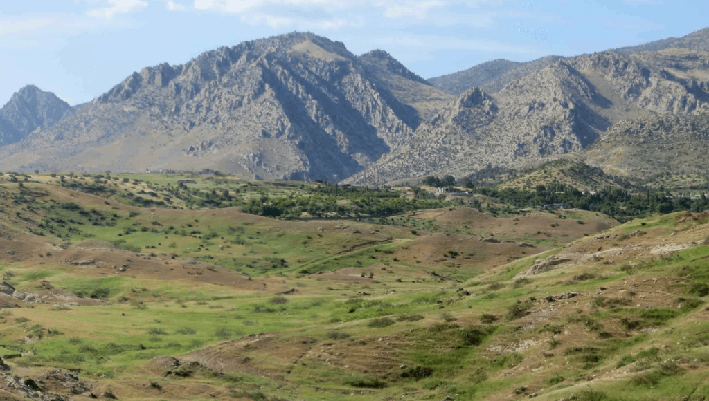
CLOSEWe have emailed you a PDF version of the article you requested.Please check your spam or junk folder You can also addnewsletters@iflscience.comto your safe senders list to ensure you never miss a message from us.CLOSEComplete the form below to listen to the audio version of this articleListenCancel and go backIFLScience needs the contact information you provide to us to contact you about our products and services. You may unsubscribe from these communications at any time.For information on how to unsubscribe, as well as our privacy practices and commitment to protecting your privacy, check out ourPrivacy PolicyAdvertisement GO AD FREE!ACCOUNTSIGN INSIGN OUTSearchBecome anIFLScience memberMY ACCOUNTTHE VAULTMY ACCOUNTTHE VAULTMAGAZINESIGN OUTTom HaleTom HaleSenior JournalistTom is a writer in London with a Master’s degree in Journalism whose editorial work covers anything from health and the environment to technology and archaeology.BookView full profileBookRead IFLScience Editorial PolicySenior JournalistFrancesca BensonCopy Editor and Staff WriterFrancesca Benson is a Copy Editor and Staff Writer with a MSci in Biochemistry from the University of Birmingham.BookView full profileBookRead IFLScience Editorial PolicyDOWNLOAD PDF VERSIONCoincidentally, the Zagros Mountains are where Homo sapiens and Neanderthals interbred between 42,000 and 49,000 years ago.Image credit: Renas KoshnawDOWNLOAD PDF VERSIONAn ancient oceanic plate under modern-day Iraq is breaking off horizontally, researchers have shown in a new study. This huge underground tear, stretching from southeast Turkey to northwest Iran, is affecting the way Earth’s surface bends and shifts, reshaping the landscape as it changes.ADVERTISEMENT GO AD FREEFor millions of years, as the Arabian and Eurasian continental plates have drifted toward each other, the underground ancient seabed that lay between them – called the Neotethys oceanic plate – has been forced deeper into the Earth. When the plates finally collided, their edges crumpled and rose, forming the Zagros Mountains. But the story doesn’t quite end there – the team of researchers behind the new study has examined how the Zagros Mountains in Iraq’s Kurdistan region have continued to morph over the past 20 million years.The weight of the Zagros Mountains causes the Earth’s surface to bend, forming depressions that fill with sediment, one example of which is Mesopotamia. However, the researchers found that the 3 to 4-kilometer (1.8 to 2.4-mile) depression filled with sediment in the southeastern area is deeper than expected. This suggests the sinking oceanic plate beneath the region is also helping to pull down the Earth’s surface, along with the mass of the hefty mountains.”Given the moderate topography in the northwestern Zagros area, it was surprising to find out that so much sediment has accumulated in the part of the area we studied. This means the depression of the land is greater than could be caused by the load of the Zagros Mountains,” Dr Renas Koshnaw, lead author and Postdoctoral Researcher at Göttingen University’s Department of Structural Geology and Geothermics, said in a statement.”This plate is pulling the region downward from below, making space for more sediment accumulation. Towards Turkey, the sediment-filled depression becomes much shallower, suggesting that the slab has broken off in this area, relieving the downward pull force,” explained Koshnaw.ADVERTISEMENT GO AD FREEIt’s likely that the Neotethys oceanic plate is effectively sinking into Earth’s mantle, the thick layer of rock that sits between the crust and core. By looking at how the inner workings of the planet are impacting the Zagros Mountain region, scientists hope to understand how deep-Earth processes shape geological features on the surface.”This research contributes to understanding how the Earth’s rigid outer shell functions,” added Koshnaw.It takes a hell of a long time, but few things in Earth’s geology remain constant. Some of the most dramatic changes over recent times can be found along the East African Rift System (EARS), one of the largest rifts in the world that stretches downward for thousands of kilometers through several countries in Africa. In 5 to 10 million years, it is possible that part of East Africa split from the rest of the continent, creating a new ocean between the divorced landmasses.The study is published in the journal Solid Earth.geology,plate tectonics,mantle,tectonic plates,planet earth,continent,Eurasia,Arabian Peninsula,Zagros Mountainslink to articlelink to articlelink to articleAdvertisement Advertisement Advertisement link to articlelink to articlelink to articleReceive weekly science coverage direct to your inbox© 2025 IFLScience. All Rights Reserved. RSS