A rare winter storm will threaten North Florida and beyond with ice and snow. What you need to know – WJXT News4JAX
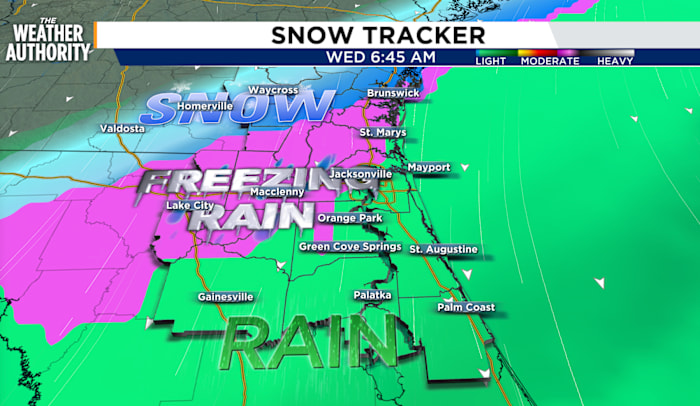
WEATHER ALERTMark Collins, MeteorologistPublished: January 20, 2025 at 1:31 PMUpdated: January 20, 2025 at 7:27 PMMark Collins, MeteorologistJACKSONVILLE, FLA – A rare winter storm is set to impact North Florida and southern Georgia on Tuesday night into Wednesday morning and it will bring the risk of ice and even some snow to the region.The greatest threat will be ice forming Tuesday night into Wednesday morning, creating hazardous travel conditions from western Jacksonville and points north and west.Here’s the breakdown:Freezing rain is expected to begin in Southeast Georgia on Tuesday afternoon before shifting south into Northeast Florida after midnight Tuesday and lingering into the mid-morning Wednesday.This poses a significant risk of ice accumulation, especially along and north of Interstate 10 toward Lake City, Macclenny, Homerville, Waycross, and Jesup.Areas along the St. Johns River and back to the beaches should not be under the risk of ice as the coastal winds help to buffer the freeze.While ice is the primary concern around Northeast Florida, snow can also target Georgia and the Florida panhandle with over an inch or more adding up on the ground.Areas along and north of Waycross in Southeast Georgia have a medium chance (40-50%) of seeing up to 1 inch of snow.There is also a low chance (5-15%) of up to 3 inches of snow north and northwest of Waycross, which could lead to major impacts.A Winter Storm Warning is in effect for snow and freezing rain late Tuesday through 1 p.m. Wednesday where the areas of greatest winter precipitation target inland Southeast Georgia, Suwanee River Valley, and near the Florida I-10 corridor.The depth of the cold above the ground explains why snow is not likely in Jacksonville.For Jacksonville to experience snow, a unique and precise combination of weather factors would need to converge — a long shot, indeed.As of now the air above the ground in Jacksonville does not look cold enough for snow even though the surface will be freezing. This vertical atmospheric profile could result in sleet or freezing rain around Duval, Nassau, and counties west along I-10.The graphic below is a cross-section of the atmosphere through time with the forecast starting on Monday at the left and ending on Sunday at the right. The white areas are temperatures below freezing in the air column over Jacksonville. Freezing air shows up Wednesday morning at the surface but since the air is not freezing aloft snow is not likely.Compared to Waycross, you can see the atmospheric sounding of air is much colder with freezing (white areas) extending from the ground to the top of the chart representing freezing air for all snow.Key Messages:Safety Actions:Consider adjusting travel plans to stay off roads after 9 p.m. on Tuesday through Wednesday morning.Copyright 2025 by WJXT News4JAX – All rights reserved.After covering the weather from every corner of Florida and doing marine research in the Gulf, Mark Collins settled in Jacksonville to forecast weather for The First Coast.emailfacebooktwitterClick here to take a moment and familiarize yourself with our Community Guidelines.Recommended VideosTV ListingsEmail NewslettersRSS FeedsContests and RulesContact UsCareers at WJXT / WCWJClosed Captioning / Audio DescriptionWJXT Public FileWJXT EEO ReportWCWJ Public FileWCWJ EEO ReportTerms of UsePrivacy PolicyDo Not Sell My InfoFCC ApplicationsCookie PreferencesIf you need help with the Public File, call (904) 393-9801.At WJXT, we are committed to informing and delighting our audience. In our commitment to covering our communities with innovation and excellence, we incorporate Artificial Intelligence (AI) technologies to enhance our news gathering, reporting, and presentation processes. Read our article to see how we are using Artificial Intelligence.Copyright © 2025 News4JAX.com is managed by Graham Digital and published by Graham Media Group, a division of Graham Holdings.