Triple-threat storm bears down on central and southern US, disrupting Mardi Gras celebrations – CNN
A powerful storm is moving across the country and spawning multiple fires and severe thunderstorms with hurricane-force wind gusts and tornadoes that are knocking out power and causing damage Tuesday. At least two people have been reported dead due to storm-related incidents.
Stretching from border to border, the storm in the central US is strengthening as it goes and putting tens of millions of people at risk of severe thunderstorms, tornadoes and fire weather on its warm, southern side, and blizzard conditions on its cold side in the Plains and Midwest.
Here’s the latest:
• Extreme fire risk: A level 3 of 3 extremely critical fire weather risk is in effect Tuesday for a large portion of Texas — including Austin and San Antonio — and part of southeastern New Mexico, according to the Storm Prediction Center. Powerful winds and very dry soil in the area are primed for “very rapid wildfire spread/extreme fire behavior,” the SPC warned. Fire departments were battling “multiple house fires” in far southern San Antonio Tuesday afternoon, as a wind-driven brush fire broke out and forced evacuations. At least 15 fires have been reported in the jurisdiction of the National Weather Service for Austin and San Antonio, which covers 33 counties, according to meteorologist Monte Oaks.
• 2 deaths and widespread power outages: Severe thunderstorms with intense damaging wind gusts are roaring across the South. At least two people died in Madison County, Mississippi, due to storm related-incidents, including one person who was electrocuted and another who died from a tree falling on a car, Coroner Alex Breeland told CNN. Wind gusts in excess of 70 mph have occurred in multiple states, including Texas, Oklahoma and Louisiana. Gusts up to 78 mph rocked the Dallas-Fort Worth Metroplex around sunrise and an 87 mph gust blew through southern Oklahoma. Over 458,000 homes and business were without power in Texas, Oklahoma, Louisiana and Mississippi by Tuesday afternoon, according to PowerOutage.us. Winds across southern and western Texas will ease significantly Tuesday night, potentially allowing fire fighters to get a better handle on the situation.
• Blizzard conditions possible: Blizzard warnings were posted Tuesday in parts of five states and were active in Nebraska. “Whiteout conditions are expected and will make travel treacherous and potentially life-threatening,” the National Weather Service in North Platte, Nebraska, warned. Additional blizzard warnings will go into effect Tuesday evening from the Kansas City, Missouri, area to just south of Minneapolis.
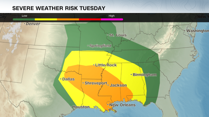
• Mardi Gras threatened: In New Orleans, officials rushed to reschedule Mardi Gras day events and shorten parade routes to avoid the potentially destructive weather. Winds were gusting to 40 mph in the city by late Tuesday morning and a high wind warning is in effect until 9 p.m. local time. The city is also under a level 3 of 5 risk of severe thunderstorms through the evening.
• Dust storm: A massive dust storm swept over swaths of New Mexico, Texas and Mexico on Monday, bringing violent winds and cloaking roadways in near-zero visibility. Officially called a haboob, the fast-moving wall of dust and debris prompted New Mexico officials to close parts of multiple interstates after the sudden wall of dust appeared to force some vehicles off the road. Dust was still blowing across the region Tuesday and could cause similar troubles, especially in Texas, as strong winds continue.
Severe thunderstorms caused significant damage to buildings and created hazardous conditions Tuesday morning across several cities in Texas – including the Dallas-Fort Worth metro area – and Oklahoma.
The Benjamin Moore paint plant in Lewisville, Texas, was damaged “in the early hours this morning, prior to any of our employees being on the property,” its spokesperson Kimberly Flores told CNN. “None of our employees were injured and we are currently assessing the damage and implications to our operating procedure.”
Strong winds also brought down trees and power lines around 5:30 a.m., leaving debris strewn across roadways and neighborhoods, according to the city’s office of emergency management.
Images shared by local businesses showed damaged vehicles and large amounts of debris near commercial properties, but police told CNN there have been no reports of injuries in Lewisville thus far.
In nearby Irving, Texas, police confirmed significant storm damage, including downed power lines.
The Atascosa County Sheriff’s Office in Jourdanton, Texas urged people to avoid an area about 30 miles south of San Antonio: “Fire departments from around the county, as well as ACSO Deputies and DPS Troopers, have responded to multiple house fires in the area of Old Pleasanton Road and Big Leaf Road that are being driven by high winds.”
The Duke fire, burning at least 50 acres near San Antonio, started around 1 p.m. and consumed 37 structures, including homes, said Bexar County Fire Chief Ralph Rodriguez during a news conference.
The fire is nearly fully contained as about 100 firefighters battle the blaze, Rodriguez said, but hotspots remain. Pleasanton Fire Department Chief Brad Chambers said at least 17 structures in the unincorporated Atascosa County were destroyed by fire, including 9 homes.
On South Padre Island, the Air and Marine Operations (AMO) said one of its aerostats broke free from its tether after experiencing “a severe wind event.”
“Due to damage occurred from the weather event, contact with the aerostat was lost shortly after breaking free,” the AMO statement said. The agency said it’s working with state and local partners and the US Coast Guard to locate the system.
An EF1 tornado tore through a community in Ada, Oklahoma, Tuesday morning, according to the National Weather Service. Images on social media showed toppled structures and widespread destruction.
A mobile home was destroyed and another was damaged, according to CNN affiliate KOCO.
In Corpus Christi, a wildfire outside the National Weather Service office forced an evacuation around 4 p.m. as wind-gusts were reported up to 6 mph, the agency said on X.
The city government urged residents to stay at home given the “significant damage,” including downed power lines, fallen trees and gas leaks. CNN affiliate KFOR reported the Union Valley Fire Department was destroyed, along with the nearby Salvation Army building.
Byng Public Schools near Ada canceled classes Tuesday due to “multiple bus routes that cannot run due to damage and debris on roads” and power outages, according to an update on Facebook.
Utility crews are working around the clock to restore power outages across both states, but officials warn restoration efforts may take time due to the extent of the damage caused by the fast-moving storm system.
The storms have also disrupted air travel: More than 500 flights within, into or out of the US were canceled and more than 2,000 were delayed by the afternoon, according to Flight Aware. Around a third of all delayed flights were either to or from Dallas-area airports.
Strong winds – gusting to 56 mph – at Dallas Fort Worth International Airport also led the Federal Aviation Administration to issue a ground stop for departures there Tuesday afternoon.
Strong tornadoes, powerful winds, hail and heavy rainfall are all possible in the Lower Mississippi River Valley through the evening.
These storms will last into the night as they track over the Southeast, with tornadoes still possible after dark. Nighttime tornadoes are nearly twice as likely to be deadly as those occurring during the day, a 2022 study found. The worst of the tornadoes are expected to hit the southeast and the National Weather Service continues to provide updates on where warnings are in effect.
Louisiana, Mississippi and parts of Arkansas, Alabama and the Florida Panhandle will likely experience the worst severe weather Tuesday. It’s in this area that strong tornadoes – rated EF2 or higher – wind gusts over 74 mph and large hail are possible.
Other parts of the Mississippi Valley and Southeast, including Birmingham, Alabama, and Atlanta, will see a slightly less intense threat for severe storms, but tornadoes, gusty winds and hail are possible in any storm Tuesday.
The wide-reaching storm will hit the East Coast Wednesday.
More than 29 million people from Florida to Pennsylvania – including Washington, DC, and Baltimore – are under a level 2 of 5 risk of severe thunderstorms, according to the SPC. Damaging wind gusts and a few tornadoes are possible within these storms.
About 8 million people in the Carolinas and southern Virginia are under a level 3 of 5 risk of severe thunderstorms. Storms in this area could unleash damaging wind gusts in excess of 75 mph and tornadoes.
Heavy rain and strong winds will impact much of the Northeast while the storm creates blizzard conditions in parts of the Midwest.
Wind gusts of 40 mph or more could occur over much of the eastern half of the US throughout the day, even outside of any wet or wintry weather.
ÔªøThese winds could wreak havoc on air travel, especially with hubs in Chicago and the New York City area impacted. More than a dozen states could also face power outages.
Much of the storm’s precipitation will come to an end Thursday, but gusty winds will persist in its wake.
CNN’s Joe Sutton, Gene Norman, Sara Smart, Dawn Sawyer and Jeremy Grisham contributed to this report.
© 2025 Cable News Network. A Warner Bros. Discovery Company. All Rights Reserved. CNN Sans ‚Ñ¢ & ¬© 2016 Cable News Network.
Source: https://www.cnn.com/2025/03/04/weather/weather-storm-south-central-us-mardi-gras-hnk/index.html