NASA Satellite Reveals Never-Before-Seen Details of the Ocean Floor – PetaPixel
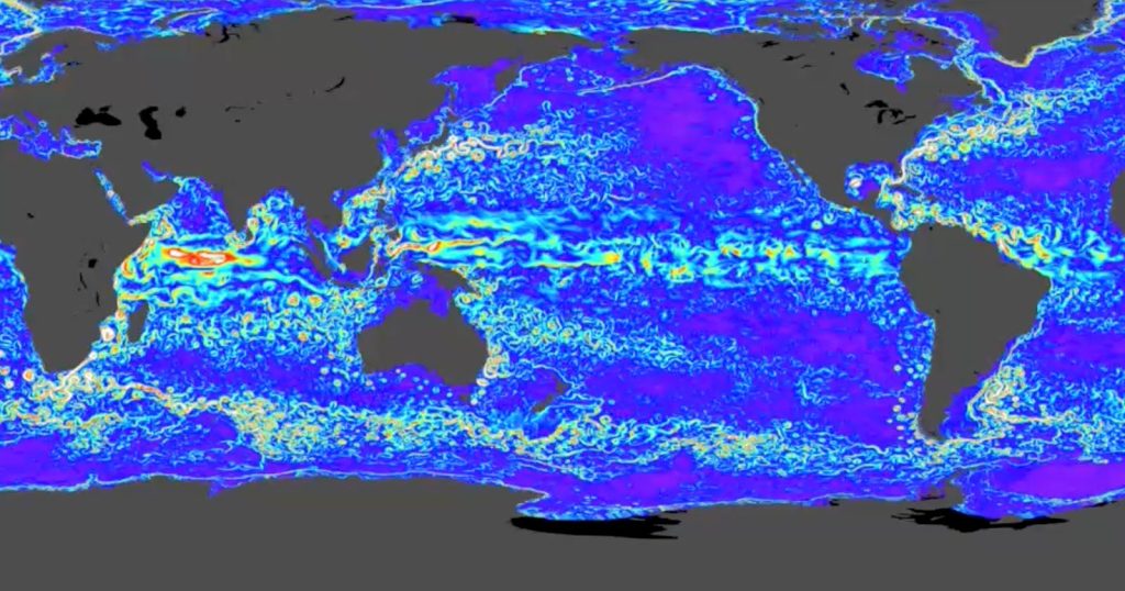
In its first year of operation, NASA’s Surface Water and Ocean Topography (SWOT) satellite has mapped Earth’s mysterious ocean floors with more detail than older satellites could over 30 years. As reported by Space the SWOT mission has achieved a lot in its first full year of operation, and scientists are already producing groundbreaking new work using SWOT’s robust dataset, including researchers Yao Yu, David T. Sandwell, and Gerald Dibarboure, who published “Abyssal marine tectonics from the SWOT mission” in Science last month. Yu, Sandwell, and Dibarboure found underwater hills and volcanoes undetectable by older satellites. The team used a year’s worth of SWOT data to “transform what may have resembled blurry blobs into discernible seamounts, ridges, and troughs,” explains the Scripps Institution of Oceanography at UC San Diego. (https://scripps.ucsd.edu/news/swot-sharpens-seafloor-focus) “In this gravity map made from merely one year of SWOT data, we can see individual abyssal hills, along with thousands of small uncharted seamounts and previously hidden tectonic structures buried underneath sediments and ice,” says Yu. “This map will help us to answer some fundamental questions in tectonics and deep ocean mixing.” SWOT features a diverse range of instruments that can detect subtle changes in ocean circulation by measuring the topography of the ocean’s surface. By measuring these changes, SWOT can measure the ocean’s internal waves, similar to how various medical imaging devices can see inside the body. The gravitational impact of large underwater structures, like volcanoes, impacts how ocean water collects and moves. Scientists can use these differences in ocean surface height to glean information about what’s beneath the water’s surface. While not as detailed as ship-mounted instruments in terms of resolution, these ship-mounted instruments have thus far been able to survey only about a quarter of the seafloor. Data concerning the remaining 75% of the ocean floor — the global ocean covers 71% of Earth, by the way — comes indirectly through satellite measurements. “With the mission still ongoing, SWOT promises critical insights for bathymetric charting, tectonic plate reconstruction, underwater navigation, and deep ocean mixing,” the researchers explain. So far, their research has focused on abyssal hills, seamounts, and continental margins (the transitional area between continental and oceanic crust). Abyssal hills are a fascinating subject, as these parallel ridges, caused by movements of tectonic plates, are typically 50 to 300 meters tall, which is not so large. With prior satellites, it was difficult to detect ocean surface differences caused by objects like this, but SWOT can. SWOT is a joint effort between NASA and the Centre National d’Etudes Spatiales (CNES) in France. Image credits: Featured image is a screenshot from a NASA SWOT video with data sourced from PO.DAAC. Become a PetaPixel Member and access our content ad-free.© 2025 PetaPixel Inc. All rights reserved.