New micro drone navigates cluttered environments at high speeds safely – Interesting Engineering
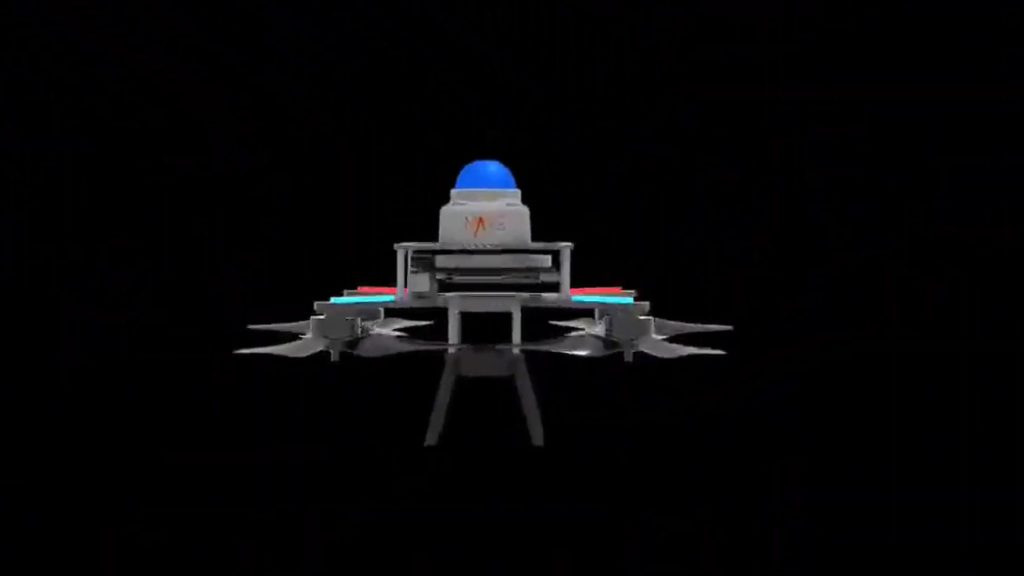
SUPER uses a lightweight 3D LiDAR for precise, long-range obstacle detection and generates safe high-speed flight trajectories from point clouds.2 days ago2 days ago2 days ago2 days ago3 days ago3 days ago3 days ago3 days ago3 days ago3 days agoan hour ago3 hours ago4 hours ago6 hours ago9 hours ago10 hours ago10 hours ago10 hours ago10 hours ago11 hours agoJijo MalayilMAV SUPER equipped with 3D LiDAR system.Science X/YouTubeEngineers at the University of Hong Kong have developed an advanced aerial robot, akin to a drone, designed for high-speed navigation in unknown environments.Unlike previous attempts, which struggled with real-time obstacle avoidance at high speeds, the model named SUPER integrates a cutting-edge perception system and AI-driven control algorithms.SUPER features a lightweight 3D LiDAR sensor for precise, long-range obstacle detection. To enable safe high-speed flight, it uses an efficient planning framework that generates trajectories directly from LiDAR point clouds.According to the team, each re-planning cycle generated two trajectories: one for safety in known free spaces and another for speed in all spaces. This approach cut failure rates by 35.9 times, reduced planning time by half, and enabled SUPER to fly over 20 m/s while avoiding thin obstacles and tight spaces.“SUPER represents a milestone in autonomous MAV (micro air vehicle) systems, bridging the gap from laboratory research to real-world applications,” said the researchers in the study abstract.Birds excel at high-speed flight through cluttered spaces with minimal failures. MAVs aim to replicate this agility for real-world applications like search and rescue. Achieving safe, high-speed flight in unknown environments requires a balance between agility, long-range sensing, and efficient trajectory planning using onboard processing.Several research projects have concentrated on speed utilizing pre-calculated trajectories or reinforcement learning, but they frequently rely on predefined environments or external sensing, which limits their practical application. By limiting flying to known free zones or slowing down near unknown places, some people put safety first. Researchers at University of Hong Kong found that a two-trajectory technique included computational delays but increased speed while preserving safety.The majority of MAVs use vision sensors to navigate. However, these are prone to motion blur, have a short range, and have trouble in dim illumination. Going beyond earlier techniques, SUPER ensures safe, high-speed flight by utilizing lightweight 3D LiDAR for long-range detection and an effective planning system.According to tests, SUPER could fly 20 meters per second across an obstacle course without incident. As it navigated a forest, the research team discovered that it could successfully avoid trees, branches, and other obstacles while following a target, like a human. They also discovered that it can function in low light because it is based on LiDAR.SUPER leverages three-dimensional LiDAR for high-speed micro aerial vehicle navigation, outperforming vision-based systems in range, accuracy, and reliability under low-light conditions. Traditional LiDAR-equipped unmanned aerial vehicles were large, heavy, and slow due to bulky, costly sensors.The aerial robot overcomes these issues using a compact, high-thrust-to-weight ratio design with a lightweight Livox MID360 LIiDAR.Unlike previous methods which rely on computationally expensive occupancy grid maps, SUPER efficiently processes LiDAR point clouds to distinguish free spaces, reducing mapping time to one to five milliseconds.It also optimizes trajectory planning using gradient-based methods instead of slow mixed-integer quadratic programming, achieving higher success rates. SUPER’s two-trajectory approach enhances safety by maintaining a backup path while optimizing switching times dynamically.Using onboard LiDAR-inertial odometry, SUPER operates independently in Global Navigation Satellite System–denied environments, making it suitable for real-world applications. These advancements allow SUPER to surpass prior LiDAR-based unmanned aerial vehicles in speed, efficiency, and adaptability.Referring to future advancements, researchers highlight that smaller, lighter LiDAR sensors with longer ranges could enhance SUPER’s agility, speed, and ability to navigate confined spaces. Improved aerodynamics and motion prediction would further boost efficiency.The team believes that with low computational demands and high-speed safety, SUPER is ideal for exploration, logistics, inspection, and search-and-rescue operations in diverse, unstructured environments.The details of the team’s study were published in the journal Science Robotics.Stay up-to-date on engineering, tech, space, and science news with The Blueprint.By clicking sign up, you confirm that you accept this site’s Terms of Use and Privacy PolicyJijo Malayil Jijo is an automotive and business journalist based in India. Armed with a BA in History (Honors) from St. Stephen’s College, Delhi University, and a PG diploma in Journalism from the Indian Institute of Mass Communication, Delhi, he has worked for news agencies, national newspapers, and automotive magazines. In his spare time, he likes to go off-roading, engage in political discourse, travel, and teach languages.a day agoa day agoa day agoa day agoPremiumIE PROFollow
Source: https://interestingengineering.com/innovation/micro-drone-unknown-terrain-high-speed