Meltwater Ponds on the Amery Ice Shelf – nasa.gov
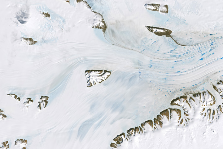
January 1, 2025JPEGToward the end of 2024, less than halfway through the melt season in Antarctica, the icy continent had already seen bouts of widespread melting along its coastal areas. By the start of 2025, meltwater remained visible atop the ice sheet’s surface, from along the Antarctic Peninsula in the west to ice shelves in the east, including East Antarctica’s Amery Ice Shelf.The OLI (Operational Land Imager) on Landsat 8 acquired these images on January 1, 2025. Several glaciers—the Lambert, Mellor, and Fisher—converge near the underlying continent’s edge. This ice flows out from the coast and onto the surface of the ocean, forming the Amery Ice Shelf and filling Prydz Bay. The shelf’s southern (interior) side, near its grounding line, is visible in the middle-right of the image above. (The entire shelf is shown in this image captured by NASA’s Terra satellite.)“The Amery is unique among Antarctic ice shelves given its long interior extent—greater than 500 kilometers (300 miles)—and extensive bordering bedrock exposures,” said Christopher Shuman, a glaciologist at the University of Maryland, Baltimore County. “Yet, even in the deep chill of East Antarctica, the change of seasons causes surface melting far inland from the coastal ice front.”Ice shelves like the Amery play an important role in holding back, or buttressing, the flow of ice from inland and upstream. Such buttressing can slow the discharge of glacial ice into the ocean, limiting contributions to sea level rise compared to unbuttressed ice areas. Thick, stable ice shelves perform this buttressing role most effectively. But when meltwater drains through fractures within the ice, it can weaken the ice shelf.January 1, 2025JPEGMelting on the ice shelf is evident in the detailed image above. The blue puddles are melt ponds—areas where the snow has melted and pooled in low spots on the shelf. Melt ponds commonly form on the Amery during the Antarctic melt season, which occurs each year from November 1 through March 31 with the rising air temperatures of austral summer. Winds can also play a role, removing winter snow and exposing bare, blue ice that is more prone to melting because its dark color absorbs more heat.The ponding visible here came after a widespread melt event around the Antarctic Ice Sheet’s margins in mid-December 2024, followed by more melting toward the end of the month that culminated in an all-time record melt extent on December 25 and 26, according to the National Snow and Ice Data Center. At that time, satellite-based passive microwave sensors detected melting across more than 3 percent of the ice sheet’s surface.Ponding on the Amery is generally limited to areas near the shelf’s grounding line, according to Wouters. He noted that closer to the ice shelf’s front (beyond this scene, to the right), ponding is prevented by colder and drier conditions that allow meltwater to refreeze within the snowpack. But research has shown, Wouters said, “that it only takes a few more degrees of warming to make these regions vulnerable to ponding.”NASA Earth Observatory images by Wanmei Liang, using Landsat data from the U.S. Geological Survey. Story by Kathryn Hansen.View this area in EO ExplorerBlue puddles of water were visible atop this East Antarctic ice shelf after periods of record melting.Image of the Day for January 21, 2025
Image of the Day
Snow and Ice
View more Images of the Day:Signs of structural weaknesses may signal a shift in this Antarctic ice shelf’s stability.
Image of the Day
Land
Snow and Ice
Image of the Day
Land
Snow and Ice
Wave action and glacial dynamics split another chunk of ice off of the Antarctic Peninsula in March 2013.
Image of the Day
Water
Snow and Ice
Ice shelves are thick slabs of ice that are attached to coastlines and extend out over the ocean. In the natural course of events, ice shelves often calve large icebergs. On February 28, 2008, however, the Wilkins Ice Shelf rapidly disintegrated into small pieces.
Image of the Day
Water
Snow and Ice
Source: https://earthobservatory.nasa.gov/images/153841/meltwater-ponds-on-the-amery-ice-shelf