NASA images show how close Eaton Fire came to NASA JPL, hundreds of homes – Fox Weather
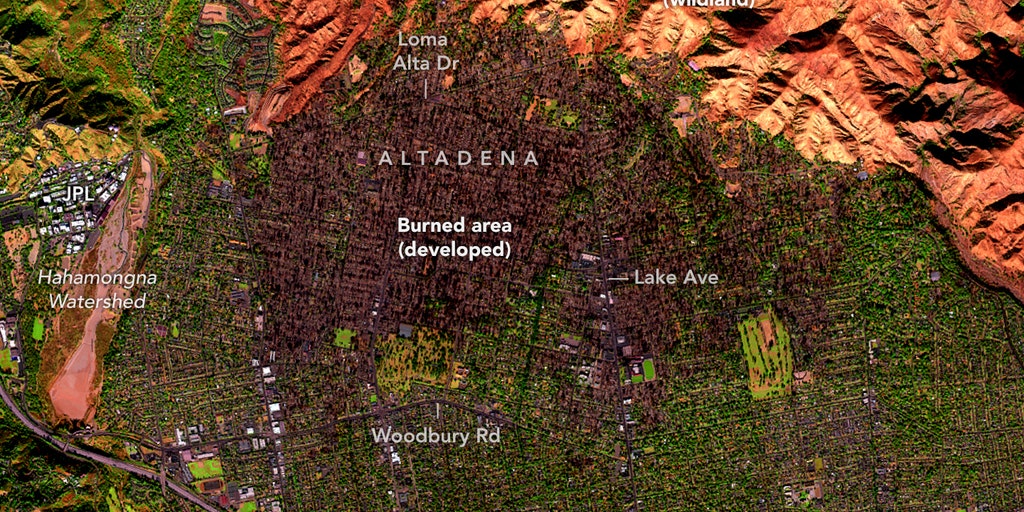
Dramatic aerial footage showed firefighting efforts in the greater Los Angeles area last week as multiple wildfires burned, causing widespread destruction and forcing tens of thousands to flee. The footage, captured by Coulson Aviation, who are contracted year-round in Southern California by LA, Ventura and Orange counties, shows aerial water drops and dramatic images of flames approaching homes.ALTADENA, Calif. – Infrared images from NASA flights over the Eaton Fire near Altadena, California show how close the fire came to hundreds of more structures, including NASA’s Jet Propulsion Laboratory, before it stopped expanding.According to NASA’s Earth Observatory, the Airborne Visible/Infrared Imaging Spectrometer (AVIRIS-3) flew on a B200 aircraft over Los Angeles on Jan. 11, capturing images of wildfire areas.The Eaton Fire erupted on Jan. 7, eventually consuming more than 14,000 acres in areas including Altadena, Pasadena, Arcadia and Sierra Madre.An image from NASA’s Airborne Visibile/Infrared Imaging Spectrometer (AVIRIS-3) instrument which flew on a B200 aircraft over the Eaton Fire in Los Angeles County, California on Jan. 11, 2025. (NASA)NASA false-color images show the charred remains of these developed areas in dark brown, and the burned wildland in the Angeles National Forest appears in orange.NASA’s JPL/Caltech campus can be seen west of the burn area. The campus has been closed since the Eaton Fire started and has been used as a staging ground for firefighting equipment. GLENDALE MAN WATCHES IN HORROR FROM SECURITY CAMERA AS WILDFIRE ENGULFS HIS HOME: ‘ALL I COULD DO’Due to the fire’s proximity to the JPL and Caltech facilities, NASA has confirmed that more than 1,000 employees, students, and faculty have been displaced by the fires. Over 270 have lost their homes to the fires.NASA’s Landsat 9 satellite captured images of the Palasides Fire burn area, which has a visibly charred stretch from light brown to dark brown to the north and west of the Pacific Palisades community.An image of the Palisades Fire burn area in false-color taken by the Operational Land Imager-2 on NASA’s Landsat 9 satellite in January 2025. (NASA Earth Observatory/Lauren Dauphin)NASA says the data from AVIRS-3 and other instruments can help investigate fire behavior and the effects of emissions on a community. NASA wildland fire program manager Michael Falkowski said the images of the Eaton Fire could help scientists understand the chemical composition and toxic nature of the ash after the fire, as well as how it moves over time via wind and water. Nearly 10 days after the deadly fire, Los Angeles County Fire officials reported that the fire was 55% contained and had stopped expanding. Thousands of structures have been destroyed by the Eaton and Palisades fires driven by furious Santa Ana winds on Jan. 7. At least 24 people died in the fires. That number will rise as urban search and rescue teams look through the debris.
This material may not be published, broadcast, rewritten, or
redistributed. ©2025 FOX News Network, LLC. All
rights reserved.
Source: https://www.foxweather.com/earth-space/nasa-images-eaton-fire-jpl