Inches added to Sunday’s snowfall predictions – 69News WFMZ-TV
Mostly cloudy with a few scattered rain or wet snow showers. .
Becoming partly cloudy overnight. Updated: January 18, 2025 @ 2:15 pmBulletin: …WINTER STORM WATCH REMAINS IN EFFECT FROM SUNDAY MORNING THROUGH
SUNDAY EVENING…
* WHAT…Heavy snow possible. Total snow accumulations between 5 and
8 inches possible.
* WHERE…Portions of east central and southeast Pennsylvania.
* WHEN…From Sunday morning through Sunday evening.
* IMPACTS…Roads, and especially bridges and overpasses, will
likely become slick and hazardous. The strong winds and weight of
snow on tree limbs may down power lines and could cause sporadic
power outages. Travel could be very difficult.
PRECAUTIONARY/PREPAREDNESS ACTIONS…
Monitor the latest forecasts for updates on this situation.
&&
Info: Type: Winter Storm Watchstart_time_local: 2025-01-19T07:00:00-05:00end_time_local: 2025-01-19T22:00:00-05:00county_name: state: PAheadline: Winter Storm Watch from SUN 7:00 AM EST until SUN 10:00 PM ESTcounty_fips: category: Meturl: urgency: Futureseverity: Severecertainty: Possiblegeographicname: Upper Bucks Countystate_name: PennsylvaniaBulletin: …WINTER STORM WATCH REMAINS IN EFFECT FROM SUNDAY MORNING THROUGH
LATE SUNDAY NIGHT…
* WHAT…Heavy snow possible. Total snow accumulations between 6 and
10 inches possible.
* WHERE…Portions of northern and northwest New Jersey and east
central and northeast Pennsylvania.
* WHEN…From Sunday morning through late Sunday night.
* IMPACTS…Roads, and especially bridges and overpasses, will
likely become slick and hazardous. The strong winds and weight of
snow on tree limbs may down power lines and could cause sporadic
power outages. Travel could be very difficult.
PRECAUTIONARY/PREPAREDNESS ACTIONS…
Monitor the latest forecasts for updates on this situation.
&&
Info: Type: Winter Storm Watchstart_time_local: 2025-01-19T10:00:00-05:00end_time_local: 2025-01-20T01:00:00-05:00county_name: state: NJheadline: Winter Storm Watch from SUN 10:00 AM EST until MON 1:00 AM ESTcounty_fips: category: Meturl: urgency: Futureseverity: Severecertainty: Possiblegeographicname: Warren Countystate_name: New JerseyBulletin: …WINTER STORM WATCH REMAINS IN EFFECT FROM SUNDAY MORNING THROUGH
SUNDAY EVENING…
* WHAT…Heavy snow possible. Total snow accumulations between 5 and
8 inches possible.
* WHERE…Portions of east central and southeast Pennsylvania.
* WHEN…From Sunday morning through Sunday evening.
* IMPACTS…Roads, and especially bridges and overpasses, will
likely become slick and hazardous. The strong winds and weight of
snow on tree limbs may down power lines and could cause sporadic
power outages. Travel could be very difficult.
PRECAUTIONARY/PREPAREDNESS ACTIONS…
Monitor the latest forecasts for updates on this situation.
&&
Info: Type: Winter Storm Watchstart_time_local: 2025-01-19T07:00:00-05:00end_time_local: 2025-01-19T22:00:00-05:00county_name: state: PAheadline: Winter Storm Watch from SUN 7:00 AM EST until SUN 10:00 PM ESTcounty_fips: category: Meturl: urgency: Futureseverity: Severecertainty: Possiblegeographicname: Western Montgomery Countystate_name: PennsylvaniaBulletin: …WINTER STORM WATCH REMAINS IN EFFECT FROM SUNDAY MORNING THROUGH
SUNDAY EVENING…
* WHAT…Heavy snow possible. Total snow accumulations between 4 and
6 inches possible.
* WHERE…Portions of east central and southeastern Pennsylvania.
* WHEN…From Sunday morning through Sunday evening.
* IMPACTS…Roads, and especially bridges and overpasses, will
likely become slick and hazardous. Travel could be very difficult.
PRECAUTIONARY/PREPAREDNESS ACTIONS…
Monitor the latest forecasts for updates on this situation. Visit
www.511pa.com for the latest travel, roadway, and traffic conditions.
&&
Info: Type: Winter Storm Watchstart_time_local: 2025-01-19T07:00:00-05:00end_time_local: 2025-01-19T21:00:00-05:00county_name: state: PAheadline: Winter Storm Watch from SUN 7:00 AM EST until SUN 9:00 PM ESTcounty_fips: category: Meturl: urgency: Futureseverity: Severecertainty: Possiblegeographicname: Schuylkill Countystate_name: PennsylvaniaBulletin: …WINTER STORM WATCH REMAINS IN EFFECT FROM SUNDAY MORNING THROUGH
LATE SUNDAY NIGHT…
* WHAT…Heavy snow possible. Total snow accumulations between 6 and
10 inches possible.
* WHERE…Portions of northern and northwest New Jersey and east
central and northeast Pennsylvania.
* WHEN…From Sunday morning through late Sunday night.
* IMPACTS…Roads, and especially bridges and overpasses, will
likely become slick and hazardous. The strong winds and weight of
snow on tree limbs may down power lines and could cause sporadic
power outages. Travel could be very difficult.
PRECAUTIONARY/PREPAREDNESS ACTIONS…
Monitor the latest forecasts for updates on this situation.
&&
Info: Type: Winter Storm Watchstart_time_local: 2025-01-19T10:00:00-05:00end_time_local: 2025-01-20T01:00:00-05:00county_name: state: PAheadline: Winter Storm Watch from SUN 10:00 AM EST until MON 1:00 AM ESTcounty_fips: category: Meturl: urgency: Futureseverity: Severecertainty: Possiblegeographicname: Monroe Countystate_name: PennsylvaniaBulletin: …WINTER STORM WATCH REMAINS IN EFFECT FROM SUNDAY MORNING THROUGH
LATE SUNDAY NIGHT…
* WHAT…Heavy snow possible. Total snow accumulations between 6 and
10 inches possible.
* WHERE…Portions of northern and northwest New Jersey and east
central and northeast Pennsylvania.
* WHEN…From Sunday morning through late Sunday night.
* IMPACTS…Roads, and especially bridges and overpasses, will
likely become slick and hazardous. The strong winds and weight of
snow on tree limbs may down power lines and could cause sporadic
power outages. Travel could be very difficult.
PRECAUTIONARY/PREPAREDNESS ACTIONS…
Monitor the latest forecasts for updates on this situation.
&&
Info: Type: Winter Storm Watchstart_time_local: 2025-01-19T10:00:00-05:00end_time_local: 2025-01-20T01:00:00-05:00county_name: state: NJheadline: Winter Storm Watch from SUN 10:00 AM EST until MON 1:00 AM ESTcounty_fips: category: Meturl: urgency: Futureseverity: Severecertainty: Possiblegeographicname: Warren Countystate_name: New JerseyBulletin: …WINTER STORM WATCH REMAINS IN EFFECT FROM SUNDAY MORNING THROUGH
LATE SUNDAY NIGHT…
* WHAT…Heavy snow possible. Total snow accumulations between 6 and
10 inches possible.
* WHERE…Portions of northern and northwest New Jersey and east
central and northeast Pennsylvania.
* WHEN…From Sunday morning through late Sunday night.
* IMPACTS…Roads, and especially bridges and overpasses, will
likely become slick and hazardous. The strong winds and weight of
snow on tree limbs may down power lines and could cause sporadic
power outages. Travel could be very difficult.
PRECAUTIONARY/PREPAREDNESS ACTIONS…
Monitor the latest forecasts for updates on this situation.
&&
Info: Type: Winter Storm Watchstart_time_local: 2025-01-19T10:00:00-05:00end_time_local: 2025-01-20T01:00:00-05:00county_name: state: NJheadline: Winter Storm Watch from SUN 10:00 AM EST until MON 1:00 AM ESTcounty_fips: category: Meturl: urgency: Futureseverity: Severecertainty: Possiblegeographicname: Hunterdon Countystate_name: New JerseyBulletin: …WINTER STORM WATCH REMAINS IN EFFECT FROM SUNDAY MORNING THROUGH
SUNDAY EVENING…
* WHAT…Heavy snow possible. Total snow accumulations between 5 and
8 inches possible.
* WHERE…Portions of east central and southeast Pennsylvania.
* WHEN…From Sunday morning through Sunday evening.
* IMPACTS…Roads, and especially bridges and overpasses, will
likely become slick and hazardous. The strong winds and weight of
snow on tree limbs may down power lines and could cause sporadic
power outages. Travel could be very difficult.
PRECAUTIONARY/PREPAREDNESS ACTIONS…
Monitor the latest forecasts for updates on this situation.
&&
Info: Type: Winter Storm Watchstart_time_local: 2025-01-19T07:00:00-05:00end_time_local: 2025-01-19T22:00:00-05:00county_name: state: PAheadline: Winter Storm Watch from SUN 7:00 AM EST until SUN 10:00 PM ESTcounty_fips: category: Meturl: urgency: Futureseverity: Severecertainty: Possiblegeographicname: Lehigh Countystate_name: PennsylvaniaBulletin: …WINTER STORM WATCH REMAINS IN EFFECT FROM SUNDAY MORNING THROUGH
LATE SUNDAY NIGHT…
* WHAT…Heavy snow possible. Total snow accumulations between 6 and
10 inches possible.
* WHERE…Portions of northern and northwest New Jersey and east
central and northeast Pennsylvania.
* WHEN…From Sunday morning through late Sunday night.
* IMPACTS…Roads, and especially bridges and overpasses, will
likely become slick and hazardous. The strong winds and weight of
snow on tree limbs may down power lines and could cause sporadic
power outages. Travel could be very difficult.
PRECAUTIONARY/PREPAREDNESS ACTIONS…
Monitor the latest forecasts for updates on this situation.
&&
Info: Type: Winter Storm Watchstart_time_local: 2025-01-19T10:00:00-05:00end_time_local: 2025-01-20T01:00:00-05:00county_name: state: PAheadline: Winter Storm Watch from SUN 10:00 AM EST until MON 1:00 AM ESTcounty_fips: category: Meturl: urgency: Futureseverity: Severecertainty: Possiblegeographicname: Northampton Countystate_name: PennsylvaniaBulletin: …WINTER STORM WATCH REMAINS IN EFFECT FROM SUNDAY MORNING THROUGH
LATE SUNDAY NIGHT…
* WHAT…Heavy snow possible. Total snow accumulations between 6 and
10 inches possible.
* WHERE…Portions of northern and northwest New Jersey and east
central and northeast Pennsylvania.
* WHEN…From Sunday morning through late Sunday night.
* IMPACTS…Roads, and especially bridges and overpasses, will
likely become slick and hazardous. The strong winds and weight of
snow on tree limbs may down power lines and could cause sporadic
power outages. Travel could be very difficult.
PRECAUTIONARY/PREPAREDNESS ACTIONS…
Monitor the latest forecasts for updates on this situation.
&&
Info: Type: Winter Storm Watchstart_time_local: 2025-01-19T10:00:00-05:00end_time_local: 2025-01-20T01:00:00-05:00county_name: state: PAheadline: Winter Storm Watch from SUN 10:00 AM EST until MON 1:00 AM ESTcounty_fips: category: Meturl: urgency: Futureseverity: Severecertainty: Possiblegeographicname: Carbon Countystate_name: PennsylvaniaBulletin: …WINTER STORM WATCH REMAINS IN EFFECT FROM SUNDAY MORNING THROUGH
SUNDAY EVENING…
* WHAT…Heavy snow possible. Total snow accumulations between 5 and
8 inches possible.
* WHERE…Portions of east central and southeast Pennsylvania.
* WHEN…From Sunday morning through Sunday evening.
* IMPACTS…Roads, and especially bridges and overpasses, will
likely become slick and hazardous. The strong winds and weight of
snow on tree limbs may down power lines and could cause sporadic
power outages. Travel could be very difficult.
PRECAUTIONARY/PREPAREDNESS ACTIONS…
Monitor the latest forecasts for updates on this situation.
&&
Info: Type: Winter Storm Watchstart_time_local: 2025-01-19T07:00:00-05:00end_time_local: 2025-01-19T22:00:00-05:00county_name: state: PAheadline: Winter Storm Watch from SUN 7:00 AM EST until SUN 10:00 PM ESTcounty_fips: category: Meturl: urgency: Futureseverity: Severecertainty: Possiblegeographicname: Berks Countystate_name: PennsylvaniaBulletin: …WINTER STORM WATCH REMAINS IN EFFECT FROM SUNDAY MORNING THROUGH
SUNDAY EVENING…
* WHAT…Heavy snow possible. Total snow accumulations between 5 and
8 inches possible.
* WHERE…Portions of east central and southeast Pennsylvania.
* WHEN…From Sunday morning through Sunday evening.
* IMPACTS…Roads, and especially bridges and overpasses, will
likely become slick and hazardous. The strong winds and weight of
snow on tree limbs may down power lines and could cause sporadic
power outages. Travel could be very difficult.
PRECAUTIONARY/PREPAREDNESS ACTIONS…
Monitor the latest forecasts for updates on this situation.
&&
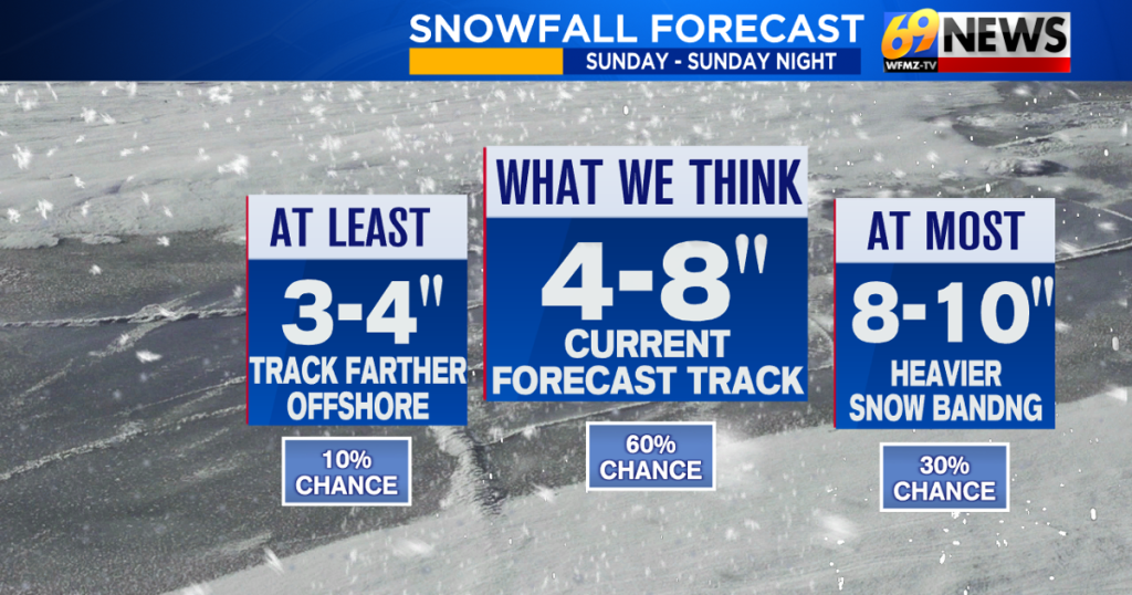
Info: Type: Winter Storm Watchstart_time_local: 2025-01-19T07:00:00-05:00end_time_local: 2025-01-19T22:00:00-05:00county_name: state: PAheadline: Winter Storm Watch from SUN 7:00 AM EST until SUN 10:00 PM ESTcounty_fips: category: Meturl: urgency: Futureseverity: Severecertainty: Possiblegeographicname: Lehigh Countystate_name: PennsylvaniaMeteorologistLatest snowfall forecast for Sunday: 4-8″ of snow expected for much of the area then bitter coldThe confidence for a snowier Sunday continues to rise, and snowfall expectations continue to rise as a result.Our area is now expected to see a widespread 4 to 8 inches of a powdery snow Sunday into Sunday night. Amounts will diminish along and southeast of the I-95 corridor and towards the shore, where mixing will factor in. But for everyone else, this is all snow, and the biggest snow of the season so far.WHAT’S CHANGED: Confidence in a stronger storm and a track closer to the coast has increased, so the snow is more likely to be steadier for much of the area. The chances for a weaker and more offshore storm track have diminished, hence the 4-8″ snowfall forecast. A few spots could see a little more than 8″ of snow, where heavier banding persists.TIMING: Snow will develop by mid to late Sunday morning, with the steadiest and heaviest snow in the afternoon and early evening. Snow will then taper off before midnight, likely by late evening. Roughly, expect a 12-hour window of snow from 10am to 10pm.TYPE: This will be an all-snow event, and a powdery snow too with the increasingly cold temperatures. That snow will blow and drift around later Sunday night and Monday as the winds pick up and the bitter cold arrives.TOTALS: Our initial forecast for 3-6″ of snow, made on Friday, has been upped to 4-8″ of snow, as confidence grows for a widespread moderate snowfall. Isolated 9″ or even 10″ amounts are possible where heavier banding sets up. The snow will be powdery, so there will be a “fluff factor” where it will be fluffy and easily accumulate.TEMPS: Temperatures will fall through the 20s as the snow falls Sunday afternoon and evening, and then into the teens overnight Sunday night. Winds will pick up later Sunday night into Monday and Tuesday, with north to northwest winds around 15-25mph and gusty, leading to wind chills as low as 10 to 20 below zero at times from Monday night through early Thursday morning. This will lead to bitter and dangerously cold wind chills.Meteorologist
Your browser is out of date and potentially vulnerable to security risks.We recommend switching to one of the following browsers:Get up-to-the-minute news sent straight to your device.