Map: Palisades and Eaton fire perimeters and evacuation zones – The Mercury News
Today’s e-EditionGet Morning Report and other email newslettersGet Morning Report and other email newslettersToday’s e-Edition
Trending: New evacuation orders continue to be issued as the Palisades Fire grew to the north and east.Related Articles
Crashes and Disasters |
Searchable map: Houses destroyed in Los Angeles’ Palisades fire
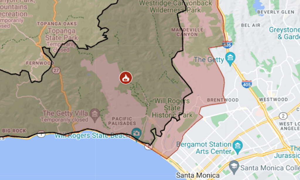
The expanded zone, 77 square miles, extended to Interstate 405 on Saturday. Some of that freeway’s interchanges were closed in Los Angeles’ Westwood and Bel Air areas.As of Saturday night, Palisades was at 23,654 acres (37 square miles) with 11% containment, the California Department of Forestry and Fire Protection said.Evacuation orders were reduced to warnings Saturday for some neighborhoods south of the Eaton Fire, as well as the Jet Propulsion Laboratory campus in La Cañada Flintridge. Burning to the north, into the Angeles National Forest, Eaton was at 14,117 acres (22 square miles) with 15% containment, CalFire said Saturday.Both Palisades and Eaton started on Tuesday, Jan. 7, a day of unusually high winds in the Los Angeles area.All evacuation orders were lifted for the Kenneth and Hurst fires, with containment around 80% for both on Saturday.For updates and details of evacuations, see the Genasys Protect map.Related Articles
Crashes and Disasters |
Searchable map: Houses destroyed in Los Angeles’ Palisades fire
Crashes and Disasters |
Could Donald Trump withhold wildfire aid from California?
Crashes and Disasters |
California’s municipal water systems aren’t designed to fight wildfires, but maybe they should be, experts say
Crashes and Disasters |
Former child star Rory Callum Sykes dies in L.A. wildfire
Crashes and Disasters |
Red flag warning points to new wildfire dangers in Southern California, lasts until Wednesday eve
The expanded zone, 77 square miles, extended to Interstate 405 on Saturday. Some of that freeway’s interchanges were closed in Los Angeles’ Westwood and Bel Air areas.As of Saturday night, Palisades was at 23,654 acres (37 square miles) with 11% containment, the California Department of Forestry and Fire Protection said.Evacuation orders were reduced to warnings Saturday for some neighborhoods south of the Eaton Fire, as well as the Jet Propulsion Laboratory campus in La Cañada Flintridge. Burning to the north, into the Angeles National Forest, Eaton was at 14,117 acres (22 square miles) with 15% containment, CalFire said Saturday.Both Palisades and Eaton started on Tuesday, Jan. 7, a day of unusually high winds in the Los Angeles area.All evacuation orders were lifted for the Kenneth and Hurst fires, with containment around 80% for both on Saturday.For updates and details of evacuations, see the Genasys Protect map.Copyright © 2025 MediaNews Group
Source: https://www.mercurynews.com/2025/01/11/map-palisades-and-eaton-fire-perimeters-and-evacuation-zones/